


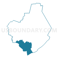
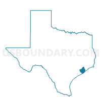
Voting District 0033, Brazoria County, Texas
About
Outline

Summary
| Unique Area Identifier | 671020 |
| Name | Voting District 0033 |
| County | Brazoria County |
| State | Texas |
| Area (square miles) | 149.71 |
| Land Area (square miles) | 117.99 |
| Water Area (square miles) | 31.72 |
| % of Land Area | 78.81 |
| % of Water Area | 21.19 |
| Latitude of the Internal Point | 28.90208080 |
| Longtitude of the Internal Point | -95.52479700 |
Maps

Graphs
Select a template below for downloading or customizing gragh for Voting District 0033, Brazoria County, Texas


Neighbors
Neighoring Voting District (by Name) Neighboring Voting District on the Map
- Voting District 0004, Brazoria County, TX
- Voting District 0006, Matagorda County, TX
- Voting District 0013, Matagorda County, TX
- Voting District 0014, Brazoria County, TX
- Voting District 0017, Brazoria County, TX
- Voting District 0020, Brazoria County, TX
Top 10 Neighboring County Subdivision (by Population) Neighboring County Subdivision on the Map
- Brazosport CCD, Brazoria County, TX (60,212)
- Brazoria-West Columbia CCD, Brazoria County, TX (32,807)
- Bay City CCD, Matagorda County, TX (23,170)
- Matagorda-Sargent CCD, Matagorda County, TX (3,301)
Top 10 Neighboring Place (by Population) Neighboring Place on the Map
Top 10 Neighboring Unified School District (by Population) Neighboring Unified School District on the Map
- Brazosport Independent School District, TX (61,787)
- Columbia-Brazoria Independent School District, TX (18,784)
- Sweeny Independent School District, TX (10,079)
- Van Vleck Independent School District, TX (4,945)
Top 10 Neighboring State Legislative District Lower Chamber (by Population) Neighboring State Legislative District Lower Chamber on the Map
Top 10 Neighboring State Legislative District Upper Chamber (by Population) Neighboring State Legislative District Upper Chamber on the Map
Top 10 Neighboring 111th Congressional District (by Population) Neighboring 111th Congressional District on the Map
Top 10 Neighboring Census Tract (by Population) Neighboring Census Tract on the Map
- Census Tract 6644, Brazoria County, TX (6,591)
- Census Tract 6628, Brazoria County, TX (6,470)
- Census Tract 6645.01, Brazoria County, TX (4,925)
- Census Tract 6629, Brazoria County, TX (4,833)
- Census Tract 6630, Brazoria County, TX (4,487)
- Census Tract 7305.01, Matagorda County, TX (3,301)
- Census Tract 7302.02, Matagorda County, TX (1,532)
- Census Tract 9900, Brazoria County, TX (0)
- Census Tract 9900, Matagorda County, TX (0)